Archeological Survey of Eressos
Conducted by GERALD P. SCHAUS
Survey Intentions
In August 1991 a thirteen-member team carried out a brief archaeological survey of the valleys surrounding the ancient city of Eressos on the southwestern coast of the island of Lesbos. The project was originally intended to last three seasons and to include, as part of its probabilistic sampling strategy, a careful surface survey along 300 x 3000 m transects covering a minimum of 20% of the lower Eressos valley and 10% of the upper Eressos valley and adjacent valleys.
Surprisingly, no intensive, systematic survey had been carried out previously on Lesbos. Since the eastern half of the island is largely covered by olive groves and pine forests, and since both the northern and eastern coasts are sensitive military areas, the south-western portion, surrounding Eressos, was deemed the most suitable for such survey work. Most of the hilly landscape is treeless and uncultivated, used only as pasturage for sheep and goats and generally surface visibility is excellent.
Transects were planned to cover the full range of environmental zones within the valleys. It was hoped to describe, map and sample sites discovered within the transects. Research using this data together with studies of the palaeobotany and geomorphology of the area was expected to provide a better understanding of the history of human occupation and resource exploitation in this part of the island. However, once the team arrived on Lesvos, they found severe restrictions of time and techniques unexpectedly imposed and had to adapt their methods accordingly.
A brief return to the island by GERALD P. SCHAUS, in 1993 allowed for the checking of details and completion of the field study, segments of which are reported here.
Because time limitations, only a portion of the planned survey area could be covered, and even this was rather superficial. This radically diminished the expected opportunities for identifying recurrent patterns in the archaeological evidence. Restrictions in the use of established survey techniques hindered the collection of data, decreased the accuracy of mapping and recording, and prevented us from recording full details of all the finds. These limitations could not be overcome; nevertheless, Schaus and his team were able to produce a report which outlines the methods and results of the survey within its limits, and suggests the potential for success which further survey effort here might expect.
These arbitrary divisions within the transects are here termed “tracts.” Because Lesbos is in a military zone, close to Turkey, detailed maps could not be obtained, nor could they safely be created. It was for this reason that long transects divided into tracts were employed. The only maps available to the team were 1:140,000 tourist maps or World War II British and German contour maps at 1:50,000. They were however, able to purchase WWII aerial photos of the entire area which could be viewed with a stereoscope for three-dimensional images. These proved highly useful, though field maps were not produced from the photos prior to the survey.
Ancient Eressos
Eressos, one of the six independent city-states established on the island in the Archaic period, has received little attention from archaeologists. Most previous work has involved observation and description of the visible surface remains. Very little archaeological excavation has been conducted, and even less publication, other than A. Orlandos’ work on two early Christian basilicas, and test trenches in areas of Skala Eresou. In recent years, excavations by the Antiquities Service have also occurred in a field to the west of the Chalandra torrent mouth and near the shore to the east of Vigla, the ancient acropolis of Eressos. The most prominent remains, besides the Christian basilicas, belong to the Classical city and include sections of fortification walls around the base of the acropolis and a harbour mole.
Remains which can safely be identified with pre-Classical inhabitants are very few indeed. A gate consisting of two large triangular rocks standing on end with a segment of polygonal wall beside them (here similar to cyclopean in appearance) is still visible on the northern slope of Vigla, but this is probably Archaic rather than Bronze Age in date, as some have thought. A few prehistoric sherds were picked up somewhere in the Eressos valley and noted by D.H. French; they were deposited in the sherd archive of the British School in Athens. The name itself, “Eresos” or “Eressos,” has been thought to belong to the group of pre-Greek place names ending in -ssos.
Ottoman Era
'Oikia's, Pottery & Coins'
By far the most common concentrations of artifacts in the Eressos area belong to this era. For the most part the remains can be associated with 'oikia’s'. These are small, rectangular, one or two-room houses built and occupied by farming families in order to be nearer their fields.
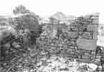
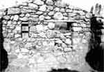
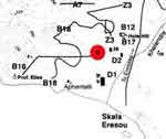
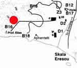
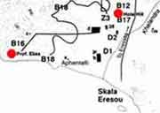
The oikia pictured above was built with stone foundations and unworked stones and pieces of terracotta tile bound with mud mortar for the walls. Large ancient, ashlar blocks are often found reused in these structures, especially at the corners, doorposts or windows. Wood is used for door and window frames, doors, shelves in wall niches, and for the ceiling/roof beams. Roofs were covered with terracotta tiles. Such oikia’s are still occupied during the summer in the area today, though many are abandoned. The oikia located at B16/6 - Map 1A - d (see below & pictured above) was built over the foundation of a Roman farmhouse as indicated by pottery and the very large grape press stone lying nearby. (see also references to the stone in 'Roman Period').
PRESS MAP TO SEE WHERE OIKIA WAS FOUND
The one- room oikia had field-stone walls bound with mud mortar preserved to a height of almost 2 m Outside dimensions were approximately 4 x 7 m, with a single door in the middle of the short side facing west with a view both towards Skala Eresos and the bay at Peristeria. Large ashlar blocks, one of which had two ancient clamp holes, were used at the corners of the oikia. The roof beams had collapsed and either rotted or been removed, leaving only a dense scatter of roof tiles on the interior and exterior of the oikia.
Abandoned water wells and ceramic kilns, which are usually found in close proximity to such oikia’s were also in evidence here dating the oikia to Roman times. The kilns were abandoned as late as this century, and apparently were used for the production of roof tiles. Finds of this type occurred at or close to the following tracts:
|
Wells |
Kilns |
|
A6 |
A3 |
|
A6 |
C4 |
|
A7 |
B16 |
|
C1 |
|
|
C3 |
|
|
B16 |
|
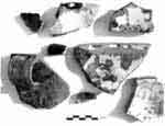 Pottery is the most common small find. A variety of fine wares were discovered, the latest having a very shiny brown glaze, which coated the interior of open shapes or the exterior of closed shapes. Occasionally pieces of undecorated white “porcelain” plates or cups were also found.
Somewhat earlier are finer pieces of china, with blue glaze decoration, though these are rare. Much more common is the so- called “Turkish” yellow- and green-glazed pottery, rarely with any decoration.
An unexpected find was the discovery of three copper 10-lepta coins of King George I ranging in date from 1869 to 1882 and a fourth copper coin (date and value not preserved) of Victor Emmanuel II (ruled 1849-1878) lying by the northwestern corner of a typical abandoned oikia in the Peristeria valley.


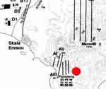
PRESS MAP TO SEE WHERE COINS WERE FOUND
Classical / Hellenistic Period
Very little was found belonging to the Greek period besides, of course, the substantial remains at ancient Eressos itself. A piece of black glaze was found at the Roman farmhouse site, and some remains east of ancient Eressos may well be Classical / Hellenistic, but there was little time to explore them further. In the latter area, i.e. the little valley and bay called Peristeria, several locations were found with higher sherd counts; these include A1, AIII, B15 and B15 (see large Map ). What is notable is that neither Roman red-slip/gloss, nor pre-modern green-, yellow or brown glaze sherds were found in these locations, which hints at a pre-Roman date. Supporting this was a black-glaze base from an open vessel found at A1, and a grey ware base fragment found at B15. A large amphora base and a handle were also found at B15.
Byzantine / Medieval Period
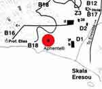
PRESS MAP ABOVE TO SEE COMPLETE SITE
There were no buildings or even scatters of pottery and other finds which could be identified with Byzantine / Mediaeval inhabitants of the valley. This does not mean that the area was uninhabited from the time the Christian basilicas at Aphentelli (see above) and Skala Eresou were destroyed and abandoned at the time the fort was built on top of Vigla, the ancient acropolis of Eressos, presumably by the Genoese, and maintained by the Turks. This 600-700 year period, no doubt one of upheaval and constant threats of piracy, is simply not in evidence, either from the 1991 survey results or indeed from other archaeological sources available at present. Church records, however, suggest that there was a bishop of Eressos during a good part of this period.
The Roman Period
Evidence for life around Eressos in the Roman period is collected by R. Levang in his 1972 dissertation, and more recently by Gerlad Schaus in a discussion of wine production in the area. Both the evidence for a profitable wine industry, from literary references and the extensive system of hillside terracing, and the impressive remains of Early Byzantine basilicas with beautiful mosaics at Aphentelli and Skala Eressos, demonstrate that the local economy was thriving until about the seventh century A.D. when the Mediterranean wine trade declined.
Lesvos may have been affected, like Chios, first by the waves of refugees from the Slav incursions into the Balkans beginning in the sixth century and then by the Arab attacks along the Anatolian coast, A.D. 654-678. It is remarkable that during the Roman period there is evidence of farm buildings scattered around the valley close to the cultivated fields and vineyards, while very little such evidence exists so far for the Archaic, Classical, and Hellenistic periods. The basilica at Aphentelli, at the western end of the beach from Eressos, may hint at wealthy patrons living near here, but no evidence for nearby landowners was known before the present survey. One apparently Roman site was located by M. Axiotes further to the north - west of modern Eressos, which presumably was a farming establishment.
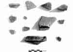
Fragments of Roman Pottery found in Eressos
Two or three places on the western side of the Eressos valley yielded Roman remains in the survey: MAP 1A D1/1, B16/1a, and B16/6. The first of these (D1/1) cannot be fixed absolutely in the Roman period since insufficient diagnostic material was gathered during our short time in the area; however, pottery shapes suggest a Roman date. It is located close to the coast on the most southerly of four isolated hills strung along the western side of the valley. Just to the east of the summit, a low wall foundation made of small stones and dirt with many sherds intermixed stretches east-west for about 10 m. Beside it to the north is a large oval depression about 0.50 m deep and a bedrock ridge beyond. The depression suggests a possible rock- cut cistern largely filled in, though there was no time to try to confirm this. No tile or brick fragments were found. The potsherds included a piece with a flat floor and a tall ring base, maybe a plate, and a piece with tall ring base, maybe a bowl. Both were of fine range clay. Two rim sherds were found with a flange inside the lip for holding a lid, perhaps from a stew pot. This was of coarser orange-pink clay. Fragments of a narrow vertical strap handle with 2 vertical grooves made of dark red clay; and 3 or 4 wall sherds of fine orange clay with spaced horizontal grooves were also found.
The Roman Farmhouse
At a second location: MAP 1A B16 c (see below) not only was a Roman farmhouse discovered (pictured above) but the clear outlines of the four terraced fields that radiate like a clover leaf away from the house were clearly discernible. The house was built on a terrace supported by an usually well-built two-meter high retaining wall constructed of very large, unworked field stones. In an enclosed area below this wall there is a deep hole largely filled with rocks in which a small fig tree grows, perhaps once the location of a well that was associated with the house. The water level is close to the surface here, judging by a watering hole excavated for local flocks half-way up the slope to the south towards the Prof. Elias chapel.
PRESS MAP ABOVE TO SEE COMPLETE SITE
From the house, one terraced field stretches up the hill to the north-east, two others stretch eastward and westward down the slope below the large terrace wall, and a fourth field climbs the hill to the south towards the modern chapel. Although it is difficult to judge where each field’s terracing ends, the fields seem to be roughly 200- 300 m long and 100-200 m wide giving a total area of roughly 15 hectares. The farm is clearly visible on air photos. A thick scattering of pottery and tiles is found around the house remains and on the slope below the large terrace wall. Little except wall foundations remain of the house itself and even these are insufficient to suggest the overall layout of the building. There are, however, at least a dozen large ashlar blocks, some still in situ, on the site. Several narrower ones are upright on their short ends, apparently in situ in a small square area close to what may be a set of broad steps. The associated pottery is clearly Roman, though a single black- glaze sherd looking very much like Corinthian fabric, was also found.
Of greatest interest is the very large press stone located 60 m to the east of the oikia. (see reference to the oikia in 'Ottoman Period') This is one of a number of such stones to be seen in the western part of the island. The archaeologist, Koldewey identified them as grape press stones, noting also the terracing on the hills all around this area which he presumed was for vineyards. The block stands over 60 cm tall, almost 1 m in length. Its top corners have been chipped away, but the square cutouts to receive wooden beams are still clear mid-way down each short side. A 15 cm ledge runs the length of the block on the northern side, parallel to the ground. Given the size of the block, it is not likely to have moved far from where it was once employed, which suggests that it is somehow associated with the foundations below the oikia and therefore with the Roman pottery nearby.
Early Bronze Age
A very long chronological gap exists between the possible Classical / Hellenistic remains and the next period for which evidence occurred in the survey, the Early Bronze Age. Two places, both on independent hills along the western side of the Eressos valley, yielded substantial remains of EBA pottery as well as hundreds of chert flakes.
PRESS MAP ABOVE TO SEE COMPLETE SITE
These are Hole Hill, seen above to the right and so named because of a small cave having both a south and a north facing entrance at the peak, and Profetes Elias Hill (seen above on the left) which lies to the North end of the beach of Eressos and has a chapel on top.
The heaviest concentration of pottery on Hole Hill was found on the saddle between the eastern and western peaks of the hill. Very little was found near the cave at the western peak which is used by sheep for cool shelter. The open, relatively flat saddle area is only about 50 m in length, offering comfortable living space to a restricted number of families. However, except for terrace walls on the slopes of the hills, and several low walls perhaps of recent centuries, there was no evidence of building on the hill.
The larger site on Prof. Elias Hill is especially remarkable since its western slope, as well as large upper and lower terraces on the north side, are heavily littered with chert debris and pottery, yet it seem to have been overlooked before now as a large Bronze Age settlement.
While Hole Hill is small by comparison, and rises only about 50 m from the valley floor, Prof. Elias Hill is large, over 160 m in height, offering level natural terraces on the northern side, a gentler slope on the western side and a saddle at about the 100 m elevation which joins northern and western sides together. Judging from the finds, it was here that a small community clustered together comfortably, largely out of sight of passing boats to the south, but perched high enough to watch the routes into the valley from all four compass points. The modern path up the hill to the chapel zig-zags up the northern side, and this no doubt was also used in antiquity, since all other ways are too precipitous for comfortable climbing. The steepness of the slope lends itself to easy defense, even on the northern side. Its distance from the coast suggests a home to farmers rather than fishermen. Until recently, the best known Early Bronze Age sites on the island have been along the North-Eastern coast, such as Thermi and Kourtir. However, several hilltop sites have now been found, including one near Agia Paraskevi.
Two other locations to the west of the Kofinas ridge yielded quantities of chert debris without any associated pottery. Other tracts in this area revealed petrified wood and high concentrations of 'chert flakes' which may indicate quarrying.
Both Hole Hill and Profetes Elias Hill also produced a small number of Ottoman green and brown glazed sherds. Neither place, however, had substantial building remains which could be associated with these finds, other than the chapel on top of Prof. Elias and some dilapidated field walls. The Early Bronze Age material was much greater in quantity. On Profetes Elias a more thorough count of surface material was undertaken by marking out a grid at 10 m intervals and counting all material within a 1 m radius of each intersection of the grid lines. This was done both for sections of the Lower Terrace and the Upper Terrace on the northern slope as well as on the western slope.
This particular study showed a heavy scatter of material. One would expect to find remains of stone walls which can be associated with this chipped stone and pottery material. On both Terraces of the northern side of Prof. Elias, animal enclosure walls have been built (now in disrepair), which no doubt made use of field stones nearby lying on the surface and obliterated surface evidence of Bronze Age walls. However, on the western slope the remains of low stone walls in the jumble of stones eroding down the slope can be seen very clearly. Only excavation can reveal whether these belonged to buildings, or if they are in fact terracing along this slope.
Prehistoric Era
One sherd from the site ( MAP 1A D1/1, B16/1a, and B16/6.) may be prehistoric. It came from a large bowl with lug handle which was vertically pierced by 2 holes; perhaps handmade, of coarse sandy clay. Low on the southern slope of this hill were found a fair number of chert flakes, likewise a sign of possible prehistoric habitation.
Survey Conclusions
The survey produced evidence of three main periods of occupation in the Eressos region. These are the Ottoman-to-Modern, the Roman, and the Early Bronze Age. To these can be added the Classical-to- Hellenistic period, when the remains of the ancient city of Eressos (around the Vigla hill) are taken into account. The Ottoman-to- Modern and the Roman periods reveal a pattern of farmhouses spread across the valleys, where landowners were more comfortable living in close proximity to their holdings, at least during part of the year.
On the other hand, during the Classical-to-Hellenistic, and the early part of the Early Bronze Age, evidence suggests that inhabitants lived in a single settlement, close by or else actually on one of the independent hills of the valley (Vigla, Hole Hill or Prof. Elias Hills), presumably because of threats from outside the region. In the Early Bronze Age, the inhabitants opted for hills at a distance from the coast, either because of danger from that direction, or because of a desire to be more centrally located with respect to their cultivated land.
The present town of Eressos, located 4 km from the coast at the junction of roads out of the valley, is perhaps no more than 300 years old. It was deliberately relocated here away from the coast for reasons unknown (perhaps because of piracy), and its population fluctuated according to the season. Many people moved, and still do, to the coast or to their farm houses in the summer. During the Ottoman-to-Modern period, therefore, there has been both a large central settlement in the valley, and a widespread scattering of individual houses close to cultivated fields.
In the Classical-to-Hellenistic period, the hill chosen was close by the shore, suggesting that a fair number of the inhabitants benefited in their livelihood from the sea, either through shipping or fishing. While tourism provides a profitable source of outside income today, focused around the lovely stretch of sand beach at the southern end of the valley, in the Classical period prosperity evidently derived from another source, the wine trade. The remarkable extent of terracing on the hills all around Eressos was only accomplished with great labour, no doubt over several centuries. The reputation of the wine of Lesbos, and in particular the wine of Eressos at this time must have created a strong outside demand with an accompanying attractive return for the extra effort needed to extend the vineyards by terracing steeper and more distant hillsides. We hear that Sappho’s brother, Charaxos (Strabo 17.1.33) was already trading Lesbian wine in Egypt by ca. 600 B.C. Since Galen (second century A.D.) and other Roman period writers continue to extol this wine, it presumably remained popular until the Mediterranean wine trade collapsed in the seventh century B.C. The large basilicas with grand mosaics both at Aphentelli and Skala Eressos might well have been paid for through the profits of the wine trade.
Finally, note should be taken of the significance of the early occupation of the valley, perhaps in the earliest part of the Bronze Age, if not earlier. No clear evidence of such early occupation had been known previously, with the exception of some sherds in the British School in Athens. Spencer and Lambrianides have recently examined the history of early occupation on the island as a whole, and revised the earlier notion that a group of people came from the coast of Asia Minor to settle first at Thermi and then spread across the island. Their study instead suggests early influence coming from two directions, from Anatolia and from the Aegean islands. If this is the case, the sites at Eressos need not be regarded simply as a result of population spread from Thermi or the eastern coast. However, much more study is needed. Sinclair Hood remarked on Blegen’s comments concerning immigrants to sites in the Troad such as Kum Tepe and suggested that these immigrants may have come from as far as Cilicia or Syria earlier than the Late Neolithic Period. It is far too early to identify the origins of the inhabitants of Eressos, but it is clear that the lovely valley must have attracted people to it then as it does now.


